Newly released satellite imagery from NASA has illustrated how frightening the extent Lake Mead’s decline has reached after years of drought.
The lake is not only the largest manmade reservoir in North America, but according to comments by Patti Aaron from the U.S. Bureau of Reclamation in a June 2 interview with PBS, 75 percent of the Mead’s water supplies an agriculture network so vast that 60 percent of all U.S. food production relies on it.
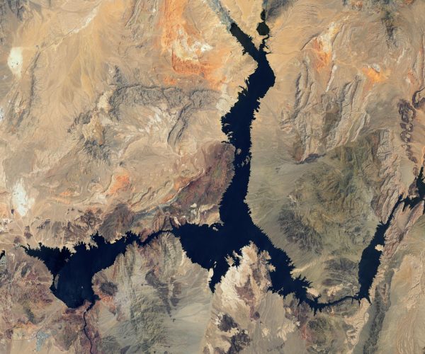
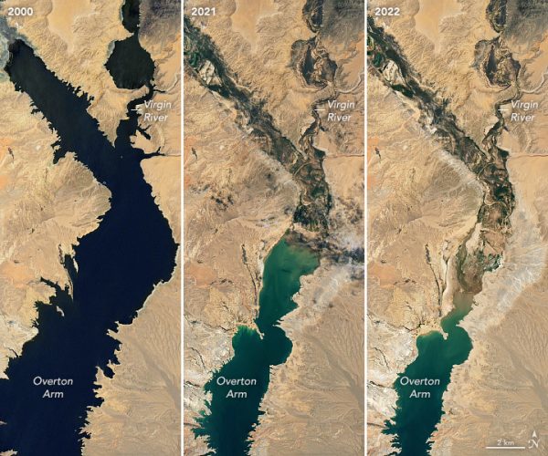
NASA’s Earth Observatory released a trio of photographs, one from 2000, another from 2021, and another from 2022, showing the extensive decline — not only in visible depth — but also in size and extensive swaths of the lake that have dried up.
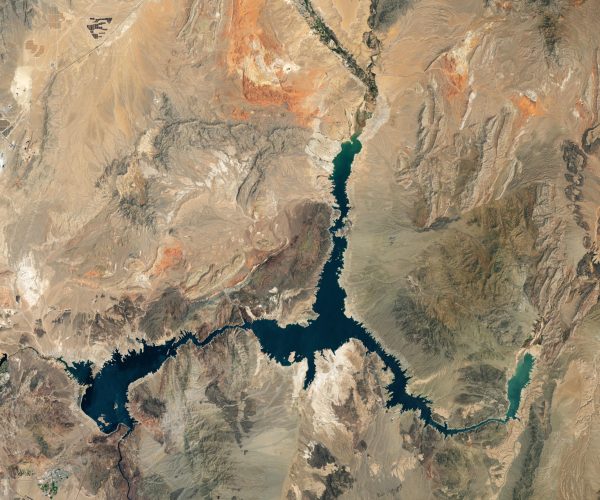
The federal agency states the photographs were taken with the Landsat 7 and Landsat 8 satellites.
While the image from 2000 shows a body of water deep blue in depth color and full, the 2021 and 2022 images show much of the lake has become shallow green.
Success
You are now signed up for our newsletter
Success
Check your email to complete sign up
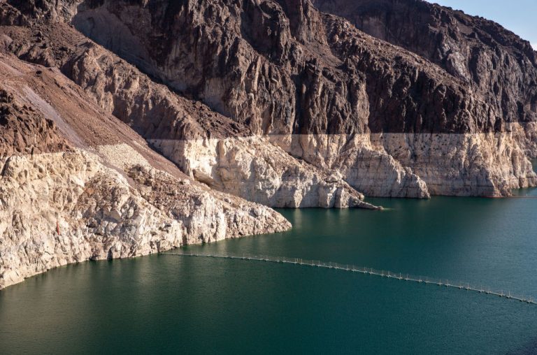
Additionally, where water once was, shorelines are now characterized by “light-colored fringes,” which NASA explains are “mineralized areas of the lakeshore that were formerly underwater when the reservoir was filled closer to capacity.”
The phenomenon is called a “bathtub ring.”
MORE ON CLIMATE DISASTER AND THE GREEN ENERGY FALLACY
- California Water Crisis to Leave 800,000 Acres of Farmland Empty This Year
- Worn-down Wind Turbines Headed to Landfills Because Recycling Is Too Expensive: Study
- Amid Record Heatwave, Europe Discovers Solar Panels Inefficient in High Temperatures
- Spanish Wildfire Sparked by Blockchain-powered Autonomous Tree Planters, Again
Based on a visual estimation of the photos, it appears that more than 10 kilometers of Lake Mead’s Northern area has totally dried while close to 20 kilometers of the Eastern area has vanished.
The U.S. Bureau of Reclamation’s data shows that Lake Mead is at its lowest level since 1987 at 1,043 feet.
Data has only been reported up to June.
The water level has already fallen nearly 25 feet this year alone.
In 2000, the water level was more than 1,200 feet, which NASA explains is close to the Lake’s capacity of 1,220 feet. At that level, the basin would hold approximately 9.3 trillion gallons of water.
The agency explains that in addition to Lake Mead’s woes, nearby Lake Powell also stands at 27 percent of its total capacity while the entire Colorado River system is at only 35 percent.
The Colorado River system is significant to Mead and Powell because snowmelt flowing through the system from the Rocky Mountain range accounts for approximately 90 percent of Lake Mead’s annual water.
The remaining 10 percent comes from precipitation and groundwater.
Tedd Florendo, Chief Meteorologist for Las Vegas 8 News Now, told PBS that people often ask him how humanity can refill the lake.
Florendo’s reply is sobering, “I need over a decade of above-average snowfall in the Colorado Rockies to make that happen.”
Lake Mead is extremely significant as it supplies a population larger than most countries, providing power and water to 25 million people.
40 million people in the San Diego, Phoenix, Las Vegas, and Los Angeles metropolises, in addition to as much as 5 million acres (7,812 sq. miles approx.) of farmland, rely on the Colorado River Basin for both hydroelectricity and water.
A May 12 article by The Conversation explains that the situation is dire, as Lake Mead is at risk of becoming a “Dead Pool,” a phenomenon characterized as when a reservoir becomes so low “that it can’t flow downstream from the dam.”
A July 18 CNN article explained that since Mead is now below 1,050 feet, a “Tier 2” shortage has been declared, limiting the amount of water that Arizona, Nevada, and New Mexico farmers may draw from the Colorado River.
Just five feet away at 1,045 feet, California becomes saddled with a reduction as well.
An August of 2021 article by Arizona State University thought that Tier 2 wouldn’t be reached until 2023.
A Tier 3 shortage is declared at 1,025 feet, and at that point residents in Arizona will endure water shortages as the government attempts to maintain stability.
On July 15, a researcher from University of California Merced told the media that preliminary findings based on satellite images revealed that already, 800,000 acres of California farmland (about 1,250 sq. miles) were left uncultivated.
The figure is not only double what went unused last year, but was found directly in the River Valley area, which accounts for a quarter of U.S. food production.