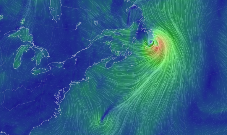
Hurricane Larry, after forming off the coast of north Africa and meandering north for several days, is expected to make landfall on the Canadian province of Newfoundland on Friday night packing winds in excess of 80 mph while creating dangerous storm surges and heavy rainfall.
A hurricane warning was issued at 9:30 a.m. on Friday Sept. 10 by The Canadian Hurricane Centre stating, “Hurricane force winds of 90 km/h (55 mph) gusting to 140 km/h (87 mph) over exposed areas on the Avalon Peninsula are expected late this evening and overnight from Hurricane Larry.”
The storm is expected to bring wind, rain, large waves and coastal flooding as it tracks over eastern Placentia Bay or the western Avalon Peninsula.
While the storm has lost intensity over the past several hours, Larry is still expected to hit Newfoundland as a category 1 hurricane and is expected to produce upwards of 2 inches of rain.
Currently, Larry is 595 miles southeast of Newfoundland and is expected to move north-northeast before turning further northeast with an increase in its forward speed.
Success
You are now signed up for our newsletter
Success
Check your email to complete sign up
The storm is expected to gradually weaken over the next day or so but will remain a hurricane as it passes over Newfoundland.
Larry’s winds extend 90 miles from its center and are producing tropical-storm-force winds upwards of 240 miles from its center.
These conditions are being characterized as “life-threatening” and are expected to topple trees, damage signs and cause property damage to roofing materials, cladding, fences and exterior fixtures.
Local flooding from heavy rainfall is also anticipated.
The strongest gusts are expected to be experienced in the St John’s metro area — Newfoundland’s capital — and will likely occur beginning at midnight on Friday until around 5:00 a.m. on Saturday morning.
“Gusty westerlies to near 80 km/h will continue through the day and into Saturday night,” the Canadian Hurricane Centre reported.


