When reading a book for the first time, finding a beautiful map among the pages is an exciting bonus that adds another dimension to the narrative. A map shows that everything is in order – it has an air of authenticity about it.
Maps started appearing in works of fiction as early as 1516, with Thomas Moore’s Utopia. The Writer’s Map, published in 2018, is a book highlighting dozens of such maps illustrating imaginary literary locations. Editor Huw Lewis-Jones explains, “for some writers, making a map is absolutely central to the craft of shaping and telling their tale.” While the map often aids the writer in his creative process, it also helps the reader to readily grasp the setting.
Creating maps
According to specialists, map reading is a crucial tool for developing children’s spatial reasoning abilities and assisting them in making sense of their surroundings. Dr. Nora Newcombe of Temple University describes spatial thinking, which includes map reading, as “seeing in the mind’s eye.” Newcombe said, “Spatial skills are what allow us to picture the locations of objects, their shapes, their relations to each other and the paths they take as they move.”
How to Train Your Dragon author Cressida Cowell describes having been inspired by maps made by 13-year-old Charlotte Brontë and her younger brother Branwell. “She drew them in tiny, beautiful books that were in themselves a fascination, for the writing was as small as if created by mice,” Cowell said. The siblings had made the tiny books based on fictional kingdoms named Angria and Glass Town.
For many writers, mapmaking is a practical endeavor that pulls them into their work. “I always draw my way into stories,” writes Abi Elphinstone, the author of the Dreamsnatcher books. “I begin every story I write by drawing a map because it is only when my characters start moving from place to place that a plot unfolds.”
Success
You are now signed up for our newsletter
Success
Check your email to complete sign up
English novelist David Mitchell also creates maps to help him through the writing, although he does not publish them. “If I’m describing a character’s ascent of a mountain, I need to know what he or she will find on the way up,” he writes, musing, “As long as I was busy dreaming of topography, I didn’t have to get my hands dirty with the mechanics of plot and character.”
Philip Pullman, author of the His Dark Materials books, finds map drawing to be the most enjoyable part of writing, as well. “Writing is a matter of sullen toil. Drawing is pure joy. Drawing a map to go with a story is messing around, with the added fun of coloring in,” he says.
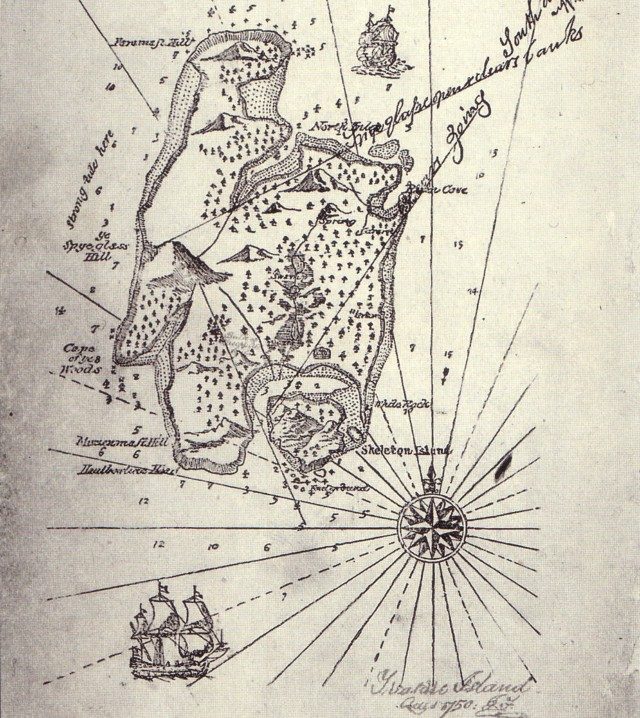
Treasure Island
This legendary adventure story was written in 1883 by Robert Louis Stevenson about pirates and hidden treasure. Treasure Island is a real-life model for the fictional location of the same name. It seems to have been a coincidental discovery for Lloyd Osbourne, Stevenson’s stepson. The family had been on vacation in a Scottish Highland cabin in the summer of 1883. Osbourne recalled how it came about:
“I happened to be tinting a map of an island I had drawn. Stevenson came in as I was finishing it, and with his affectionate interest in everything I was doing, leaned over my shoulder, and was soon elaborating the map and naming it. I shall never forget the thrill of Skeleton Island, Spyglass Hill, nor the heart-stirring climax of the three red crosses! And the greater climax still when he wrote down the words “Treasure Island” at the top right-hand corner! And he seemed to know so much about it too – the pirates, the buried treasure, the man who had been marooned on the island … . “Oh, for a story about it”, I exclaimed, in a heaven of enchantment …”
Stevenson said that when he started drawing the map, the pirates “began crawling out of the map, Long John Silver with his cutlass between his teeth.” Thus Treasure Island began; a backstory to the map drawn by Stevenson’s stepson.
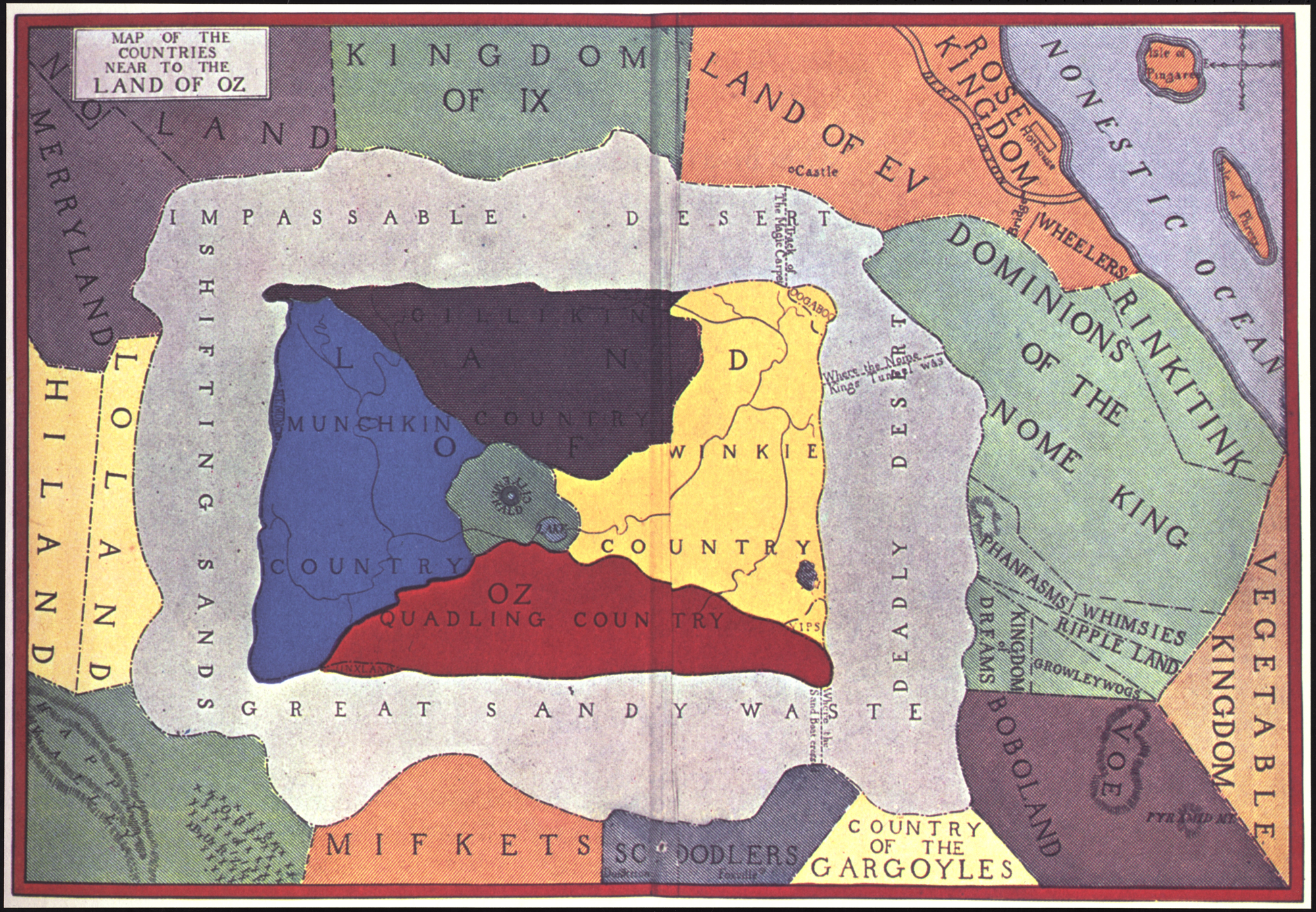
The Wizard of Oz
The Wonderful Wizard of Oz, a novel by L. Frank Baum first published in 1900, was influenced by the real-life economic hardships during the Gold Standard era in the United States. Each character in the story symbolizes a person or organization that was active in the late 1800s. This book was the first in a series of 14 books, all set in the Land of Oz.
While the Yellow Brick Road is the only way to get to Emerald City, there are several traps along the way, including the Fighting Trees, Knooks, Rampsies, Gigans, and Hammer-Heads; so a map is essential for navigating the Land of Oz.
The eighth book in the series, Tik-Tok of Oz, published in 1914, was the first to incorporate a map. Oddly, East and West are reversed on the rose compass of this “official” map, making it a source of debate for the last century. Was this a genuine mistake? Or is it possible that directions in Oz are actually reversed? Dorothy seemed to have her bearings straight as they headed back to the Emerald City. Perhaps the message is to follow your heart. At the end of the day, you choose your own path based on the map you believe to be true.
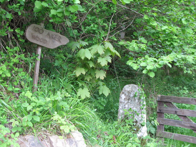
Winnie-the-Pooh
When illustrator E.H.Shepard first drew the map of the 100 ‘aker’ wood, he based the topography of the wood on Ashdown Forest, the actual landscape situated near Cotchford Farm, the Milnes’ home in East Sussex.
A. A. Milne’s Winnie-the-Pooh is an anthology of children’s tales first released in 1926, including its sequel, The House at Pooh Corner (1928.) He dedicated the books to his young son, Christopher Robin.
The main character, Winnie-the-Pooh, affectionately known as Edward Bear or just Pooh, is an amicable, yellow-furred bear who loves honey. Pooh lives in Hundred-acre wood, which now comprises such locales as Owl’s House, Pooh’s House, Piglet’s House, Pooh Corner (which became Pooh & Piglet Corner in Piglet’s Big Movie), Rabbit’s House, and Tigger’s House.
This map has shaped reality to some degree. If you happen to be in the area, explore Ashdown Forest– you may come upon Piglet’s beech tree or Anga and Roo’s cottage in a sandy area near Gill’s Lap. Pooh’s discovery of the ‘North Pole’ is located east of Gill’s Lap. Poohsticks Bridge, also known as Posingford Bridge, is the most well-known landmark in the area.