According to data released on May 24 by the National Oceanic and Atmospheric Administration (NOAA) Americans need to brace for another above average Atlantic hurricane season this year.
The NOAA’s Climate Prediction Center, a division of the National Weather Service, expects this year to be the seventh consecutive above-average hurricane season and an ocean phenomenon known as a “Loop Current” threatens to make this year’s hurricane season much more destructive.
The Atlantic hurricane season begins on June 1 and extends out to November 30.
NOAA is forecasting a 65 percent chance that this year’s hurricane season will be above average. There is a 25 percent chance of near normal activity and only a 10 percent chance of below normal hurricane numbers.
According to the National Hurricane Center, in a typical year, the Atlantic hurricane season produces 14 named storms, seven of which are considered normal hurricanes and three of which are considered major.
Success
You are now signed up for our newsletter
Success
Check your email to complete sign up
This year the agency says it is predicting a 70 percent chance of 14 to 21 named storms, six to 10 of which will evolve into hurricanes and of these three to six will intensify into a major hurricane of Category 3 or greater.
The predictions are based on several factors including sea level temperatures in the North Atlantic Ocean Basin and the presence of a La Niña event in the Pacific Ocean.
La Niña events have become more common over the previous decades. They are an oceanic and atmospheric phenomena that results in lower sea surface temperatures across the eastern equatorial part of the central Pacific Ocean.
The events impact the climate differently depending on the region of the globe but in North America they typically result in above-average precipitation across the northern Midwest, the northern Rockies, Northern California and the Pacific Northwest’s southern and eastern regions.
‘Loop Current’ could make this year’s hurricane season more destructive
Top of mind for forecasters though is an ocean phenomenon known as a “Loop Current.”
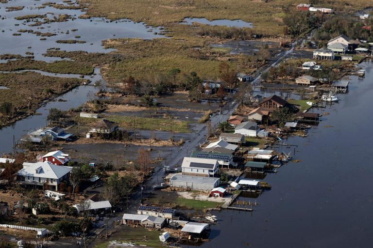
Loop Currents have the potential to turbo-charge already destructive hurricanes. Two of the most damaging hurricanes to ever make landfall in the United States were driven by Loop Currents; Hurricane Opal in 1995 and Hurricane Katrina, a category five hurricane which caused $100 billion worth of damages when it made landfall in New Orleans in 2005.
This current balloons into the Yucatan Channel deep into the Gulf of Mexico and exits through the Straits of Florida. Experts say this year the current has pushed much farther north than what is typical.
According to the NOAA, “When the Loop Current is extended, it eventually sheds a large eddy, or Ring, which then drifts westward, whereas the Loop Current retracts to the south.”
An eddy from a Loop Current is what caused Hurricane Katrina to intensify beyond a normal tropical storm into a category five hurricane.
Should a tropical storm pass over a Loop Current it could strengthen the storm into a powerful hurricane within hours.
Professor Nick Shay, from the University of Miami, who has been monitoring ocean heat content for more than 30 years said the conditions currently in the Gulf “are cause for concern.”
He told Sky News, “When the Loop Current reaches this far north this early in the hurricane season — especially during what’s forecast to be a busy season — it can spell disaster for folks along the Northern Gulf Coast, from Texas to Florida.”
Shay said it was because of a Loop Current that Hurricane Ida, which made landfall in August 2021, exploded “almost overnight” due to its surface temperature of over 30° C (86°F) which extended down to about 180m (590ft) below the ocean’s surface.
By mid-May this year, the Loop Current had already pushed water temperatures up to around 25° C (78° F) which Shay says “can create towering plumes of rising warm, moist air, providing high-octane fuel for hurricanes.”
“As more moisture and heat rise within a hurricane, the pressure drops. The horizontal pressure difference from the centre of the storm to its periphery subsequently causes the wind to speed up and the hurricane to become increasingly dangerous,” Shay said.
Deanna Criswell, the administrator of the U.S. Federal Emergency Management Agency (FEMA) said, “It’s important for everyone to understand their risk and take proactive steps to get ready now.”